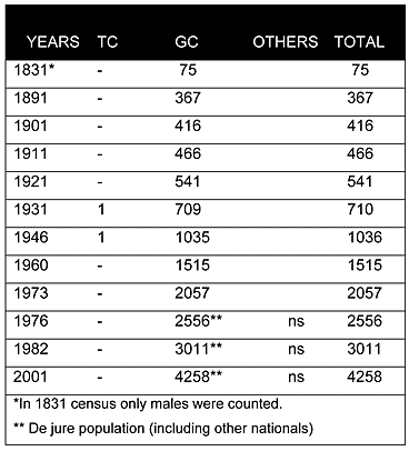
As can be seen from the chart above, in the Ottoman census of 1831, the village was only inhabited by Greek Cypriots. Throughout the British period as well, Sotira remained a solely Greek Cypriot village. During the latter period, the population of the village steadily increased from 367 in 1891 to 1,515 in 1960. The last recorded census of 2001 puts the population at 4,258.
Displacement:
From its original population no one was displaced; however, after 1974, the village served as a reception centre for displaced Greek Cypriots, mainly from the Famagusta district. In the late 1970s, the Republic of Cyprus built some refugee housing complexes in the village for those displaced people who had been living in the refugee camps situated in the vicinity of the village.
Current Inhabitants:
Today the village is primarily inhabited by its original inhabitants and many displaced Greek Cypriots from various villages in the Famagusta district.
Websites: