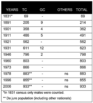

As can be seen from the chart above, in the Ottoman census of 1831, Muslims (Turkish Cypriots) constituted the only inhabitants of the village. Throughout the British period the village was solely inhabited by Turkish Cypriots, apart from a handful of Greek Cypriots who appear in the records at various points. During the 20th century, the village’s population increased considerably, from 362 in 1901 to 803 in 1960.
Displacement:
From its original population no one was displaced; however, the village served as a reception centre for displaced Turkish Cypriots in 1964. From 1964 to 1974, it was administratively part of the Turkish Cypriot enclave of Mora/Meriç(071). Geographer Richard Patrick estimated the village’s population at 880 in 1971, a rise from 803 in 1960. He also claimed that there were twelve displaced Turkish Cypriots still living in Sinta in 1971.
Current Inhabitants:
Currently the village is mainly inhabited by its original villagers. Some displaced Turkish Cypriots from surrounding villages in the 1960s have also remained in the village, and some Turkish families from Turkey chose to move to the village after 1975. Recently some Turkish Cypriot returnees from England have chosen Sinta/İnönü as a location to build homes and settle. The 2006 Turkish Cypriot census puts the population at 933.
Websites: