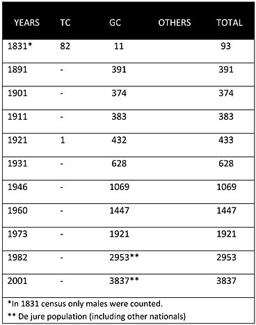
As can be seen from the chart above, in the Ottoman census of 1831, the village was a mixed village, the majority being Muslims (88%). In 1862, the historian Mas Latrie also classified the village as a Muslim village. However, from the beginning of the British period the village was solely inhabited by Greek Cypriots. It is believed that most of the inhabitants of the village were crypto-Christian (Linobambaki) until the British arrival. The 1881 British census mentions their return to Christianity. The village’s population steadly increased from 452 in 1891 to 1,867 in 1960. The last recorded census of 2001 puts the population at 3,837.
Displacement:
From its original population no one was displaced; however, after 1974, the village served as a reception centre for many displaced Greek Cypriots, mainly from the Famagusta district. By 1976, the Republic of Cyprus developed and built many refugee housing units in the vicinity of the village.
Current Inhabitants:
Today the village is mainly inhabited by its original inhabitants and many displaced Greek Cypriots from various areas in the Famagusta district.
Websites: