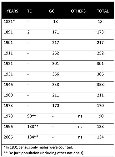
As may be seen from the chart above, in the Ottoman census of 1831, Christians (Greek Cypriots) constituted the only inhabitants of the village. Throughout the British period the village was solely inhabited by Greek Cypriots. Its population steadily increased from 217 in 1901 to 358 in 1946, though afterwards, the 1960 census recorded a significant drop, to 211. The last recorded census (1973) before the 1974 war put the population at 170, demonstrating a further decline.
Displacement:
All of the village’s inhabitants were displaced in 1974. Most fled between July and August of that year from the advancing Turkish army to the southern part of the island. Currently, like the rest of the displaced Greek Cypriots, the Greek Cypriots of Gerani are scattered throughout the island’s south, with large pockets in towns. The number of the Gerani Greek Cypriots who were displaced in 1974 was around 170.
Current Inhabitants:
Today the village is mainly inhabited by Turkish nationals who settled there in 1976. They are mainly from the Konya and Denizli provinces of Anatolia. The 2006 census puts the village’s population at 134.
Websites: