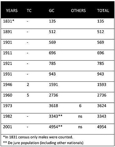
As can be seen from the chart above, in the Ottoman census of 1831 the village was solely inhabited by Christians (Greek Cypriots). Throughout the British Period the village continued to be predominantly inhabited by Greek Cypriots. Its population steadly increased from 569 in 1901 to 2,736 in 1960. The last recorded census of 2001 put the population at 4,954.
Displacement:
From its original population, some inhabitants of upper Deryneia were displaced; all the same, after 1974, the village also served as a reception centre for displaced Greek Cypriots (mainly from Famagusta district). Deryneia municipality claims that apart from 1,000 persons who fled upper Deryneia and settled in lower Deryneia in 1974, there are also another 600 refugees mainly from the city of Famagusta currently living in Deryneia.
Current Inhabitants:
Today the village is mainly inhabited by its original inhabitants and displaced Greek Cypriots from the Famagusta district.
Websites: