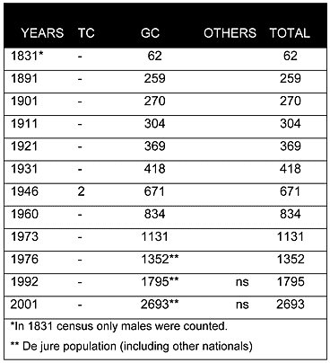
As can be seen from the chart above, since the 19th century the village has been solely inhabited by Greek Cypriots. During the 20th century, the village’s population showed an upward trend in its growth rate. Agia Napa’s population steadily increased from 259 in 1891 to 834 in 1960. The last recorded census, in 2001, puts the population at 2,693.
Displacement:
From its original population no one was displaced; however, after 1974 the village served as a reception centre for many displaced Greek Cypriots, mainly from the Famagusta district.
Current Inhabitants:
Today the village is mainly populated by its original inhabitants, Greek Cypriot returnees from overseas, and many displaced Greek Cypriots from the Famagusta district and the city of Famagusta. During the last twenty years, many European citizens have also bought property and settled here. The 2001 census puts the village’s population at 2,693. Due to the summer homes built in the village, the population can easily rise to 6,000 during the holiday seasons, not including tourists staying in the area’s many hotels.
Websites: