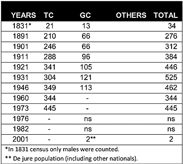
As may be seen from the chart above, Souskiou was a mixed village from the Ottoman period. During the British period, the population of the village increased steadily from 210 in 1891 to 462 in 1946. After the departure of the Souskiou Greek Cypriots in 1958, the overall population dropped to 344 in 1960.
Displacement:
All the Greek Cypriots of the village were displaced during the emergency years of the 1950s. During the intercommunal strife of 1963-64, Souskiou became an important stronghold of Turkish Cypriot Fighters. It also served as a reception center for some displaced Turkish Cypriots from Kidasi/Ceyhan(310) during this period. On 21 July 1974, at the beginning of the Turkish military offensive in the island, Souskiou was evacuated. Some of the fighters and their families sought refuge in Stavrokonnou/Aydoğan(338) village and stayed there until the village was evacuated in September 1975. Some also fled secretly over the mountains to the British Base Area and were eventually taken to the northern part of the divide via Turkey in January 1975. They were mainly resettled in Kythrea/Değirmenlik(056), a village in the Nicosia district. However some of them also chose to be resettled in the towns, such as Famagusta(140), Kyrenia(236) and Morphou/Güzelyurt(072), or the villages,of Fyllia/Serhatköy(035), Masari/Şahinler(068), Akanthou/Tatlısu(126) and Lysi/Akdoğan(167). The number of Souskiou/Susuz Turkish Cypriots who were displaced after 1974 was around 350-370 (344 in the 1960 census).
Current Inhabitants:
The village is now empty and in ruins. Some of the houses are used as sheepfolds.
Websites: