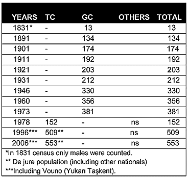
As can be seen from the chart above, in the Ottoman census of 1831, Christians constituted the only inhabitants of the village. Its population steadily increased from 134 in 1891 to 356 in 1960.
Displacement:
All of the village’s inhabitants were displaced in 1974, as between July and August 1974 they fled from the advancing Turkish army to the southern part of the island. Currently, like the rest of the displaced Greek Cypriots, the Greek Cypriots of Sichari are scattered throughout the island’s south, with small pockets in towns. The number of the Sichari Greek Cypriots who were displaced in 1974 was around 390 (381 in the 1973 census).
Current Inhabitants:
Today the village is mainly inhabited by displaced Turkish Cypriots from the island’s south, especially from the village of Tokhni/Taşkent(374), but also from Limassol(269) and Kalavasos(355). There are also some Turkish nationals living in the village. The 2006 Turkish Cypriot census puts Taşkent’s population, including the inhabitants of both Vouno/Taşkent and Sykhari/Aşağı Taşkent villages, at 553.
Websites: