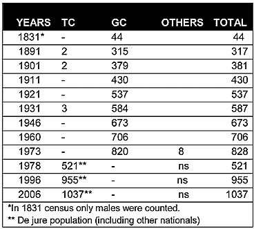
As can be seen from the chart above, in the Ottoman census of 1831, Christians constituted the sole inhabitants of this settlement. At the turn of the century there were only one or two Muslim inhabitants living in the village. The population shows a steady increase during the British period, growing from 317 in 1891 to 706 in 1960.
Displacement:
All of its inhabitants were displaced in 1974, as between July and August 1974 they fled from the advancing Turkish army to the southern part of the island. Currently, like the rest of the displaced Greek Cypriots, the Greek Cypriots of Myrtou are scattered throughout the island’s south, with some pockets in cities. The displaced population of Myrtou can be estimated at around 820-830, since its Greek Cypriot population was 820 in 1973.
.
Current Inhabitants:
In 1975, the village was used for the settlement of displaced Turkish Cypriots from the southern part of the divide. They are mainly from Androlikou/Gündoğdu(292), Fasli/Fesli(302) and Prodromi/Karşıyaka(334), all villages in the Polis area of Paphos. In the 1996 census, more than half of the 535 Turkish Cypriots of the village showed south Cyprus as their place of birth. The village also hosts a military camp, and some of its houses are used by military personnel and their families.
Websites: