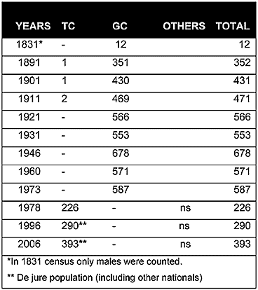
As can be seen from the chart above, in the Ottoman census of 1831, Christians constituted the only inhabitants of the village. At the turn of the century there were only one or two Muslim inhabitants in the village. Although the population showed a slight increase during the first half of the 20th century, a slight drop was recorded after 1946.
Displacement:
All of the village’s inhabitants were displaced in 1974, fleeing from the advancing Turkish army to the southern part of the island in July and August. Currently, like the rest of the Greek Cypriot refugees, the Greek Cypriots of Kalograia are scattered throughout the island’s south, with small pockets in towns. The number of the Greek Cypriots who were displaced in 1974 was around 590 (587 in 1973).
Current Inhabitants:
This village was used for the settlement of Turkish nationals from Turkey in 1975, mainly from Gülnar in southern Turkey and Araklı on the Black Sea coast. According to the 2006 census the population of the village was 393. During the last five years, many Turkish Cypriots and European citizens have bought property and settled in the vicinity of the village.
Websites: