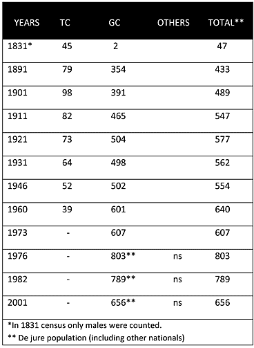
As explained above, until 1964, the village was mixed, with a small Turkish minority. However, in the Ottoman census of 1831, Muslims (Turkish Cypriots) constituted almost the sole population of the village. Whether this recording was a mistake on the part of the census takers needs to be determined, because only five decades later, in the 1891 British census, the Greek Cypriots constituted almost 82% of the population. Throughout the twentieth century, while the Greek Cypriot population increased steadily, the Turkish Cypriot population fluctuated and eventually declined. In 1960, the Turkish Cypriot share of the population had fallen to only 6%.
Displacement:
The only conflict-related displacement took place during the intercommunal disturbances in 1964. In January 1964, all the Turkish Cypriots of the village fled and sought refuge in other villages or towns solely controlled by Turkish Cypriots, such as Mora/Meriç(071) and Lefka/Lefke(060). None of the Turkish Cypriots from this village returned. Currently, most of the Turkish Cypriots of Orounta are living in the village of Katokopia/Zümrütköy(048), almost twenty kilometers northwest of Orounta but situated on the other side of the divide.
Current Inhabitants:
Currently the village is mainly inhabited by its original Greek Cypriot villagers and some displaced Greek Cypriot from the north. The 2001 census put the village’s population at 656.
Websites: