Pano Koutrafas was a small Turkish Cypriot hamlet situated in the Orinis region of the Nicosia district, three kilometers south of Kato Koutrafas and three kilometers north of Nikithari. According to Goodwin, the village was named after its first inhabitant. He also claims that Koutrafa means “someone who likes eating capers.” Koutrouvi in Greek is capers. In 1958, Turkish Cypriots adopted another name for the village, Kurtboğan, literally meaning “a person who strangles wolfs.”
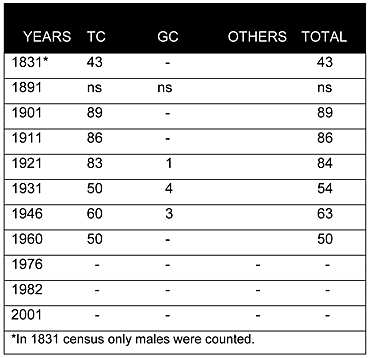
From 1831 to 1960, the village was almost solely inhabited by Turkish Cypriots. Although the population increased in the first decades of the British period, ultimately there was a steady decrease from 89 in 1901 to 50 in 1960.
Displacement:
Due to the intercommunal disturbances of 1963-64, all the Turkish inhabitants of Pano Koutrafas/Kurtboğan were displaced. They mainly sought refuge in the Turkish Cypriot enclave of Lefka/Lefke(060), including the villages of Angolemi/Taşpınar(018) and Kazivera/Gaziveren(049). They remained in those locations until 1974. Currently, Turkish Cypriots from this village are scattered around different parts of north Cyprus, with a relatively large pocket in Pentagiea/Yeşilyurt(084).
Current Inhabitants:
According to Goodwin, immediately after the 1974 war, some of the houses were occupied by displaced Greek Cypriots from the north for a short period of time. However, by 1979, there was no one living there. The village has remained abandoned; all of its houses and buildings are currently in ruins.
Websites: