Agioi Iliofotoi, Eliophotes, or Alifodes, was a small hamlet situated on the northern foothills of the Troodos mountain range, two kilometers northwest of Mitsero and one kilometer southeast of Kato Moni . A common claim is that the village was named after German saints who came to Cyprus in the fifth century. Turkish Cypriots adopted the alternative name of Zeytinlik in 1958, literally meaning “olive orchard.” They appear to have chosen this name based on an alternative interpretation of the Greek etymology, associating the name with the Greek word “elea,” or “olive.”
Historical Population:
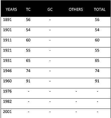
Although there had been a functioning church in the village since 1881, the village was solely inhabited by Turkish Cypriots. The church was used only for pilgrimages and Sunday masses for the Orthodox Christians from nearby villages. The population fluctuated in the first decades of the 20th century but steadily increased from 56 in 1891 to 91 in 1960.
Displacement:
All the Turkish inhabitants of Agioi Iliofotoi/Zeytinlik were displaced on 24 January 1964. Most of the villagers sought refuge in the Nicosia enclave and soon after were moved to a refugee camp in Krini/Pınarbaşı(235) on 25 January. Apart from one family who returned to the village in the early 1970s, all the Turkish Cypriots of Agioi Iliofotoi/Zeytinlik remained in Krini/Pınarbaşı(235) until December 1974, when they were resettled in the villages of Katokopia/Zümrütköy(048) and Vasileia/Karşıyaka(252).
Current Inhabitants:
The village has remained abandoned since 1964; all of its houses and buildings were razed to the ground in the late 1970s. The only surviving building in the village is the church of Agioi Iliafotoi.
Websites: